Back سبايكينيسه Arabic سپيچكينيسى ARZ Spijkenisse Catalan Spijkenisse CEB Spijkenisse German Spijkenisse Esperanto Spijkenisse Spanish Spijkenisse Basque اسپیکنیسه Persian Spijkenisse Finnish
Spijkenisse | |
|---|---|
 Town centre of Spijkenisse | |
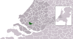
 Location in South Holland | |
| Coordinates: 51°51′N 4°20′E / 51.850°N 4.333°E | |
| Country | Netherlands |
| Province | South Holland |
| Municipality | Nissewaard |
| Area | |
• Total | 30.27 km2 (11.69 sq mi) |
| • Land | 26.12 km2 (10.08 sq mi) |
| • Water | 4.15 km2 (1.60 sq mi) |
| Elevation | −1 m (−3 ft) |
| Population | |
• Total | 72,500 |
| Demonym | Spijkenissenaar |
| Time zone | UTC+1 (CET) |
| • Summer (DST) | UTC+2 (CEST) |
| Postcode | 3200–3209 |
| Area code | 0181 |
| Website | www |
Spijkenisse (Dutch pronunciation: [spɛikəˈnɪsə] ⓘ) is a large town in the province of South Holland, Netherlands. Following an administrative reform in 2015, it is part of the municipality of Nissewaard, and has a population of 72,500. It covers an area of 30.27 km2 (11.69 sq mi) of which 4.15 km2 (1.60 sq mi) is water. It is part of the Greater Rotterdam area.
- ^ "Kerncijfers wijken en buurten 2020" [Key figures for neighbourhoods 2020]. StatLine (in Dutch). CBS. 24 July 2020. Retrieved 19 September 2020.
- ^ "Postcodetool for 3201EL". Actueel Hoogtebestand Nederland (in Dutch). Het Waterschapshuis. Retrieved 24 August 2013.

